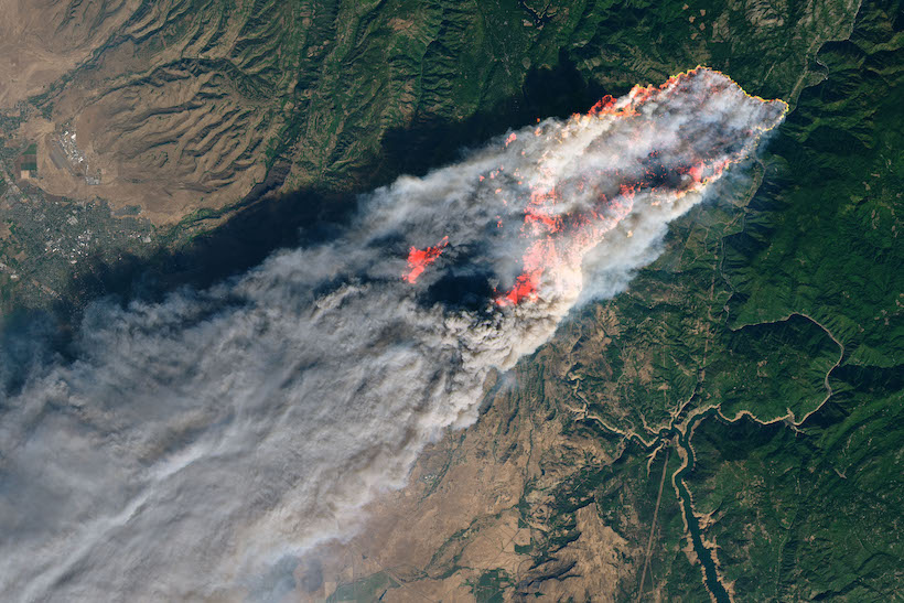
© NASA Worldview, Earth Observing System Data and Information System (EOSDIS)
NASA Reveals Spectacular Photos Of The California Blazes From Above
86 Dead, 560 Still Missing in the California Wildfires. An entire city wiped and out hundreds of acres scorched, since July, California has been hit with a series of blazes of an unprecedented intensity.
The wildfire began in the northern part of the state, in Butte County, on November 8. Known as “Camp Fire”, it has now become the deadliest fire in the state history. In the south, “Woosley Fire” and “Hill Fire” are still going, devastating a part of the territory around Los Angeles.
Even around all of the destruction, NASA just revealed satellite natural-colour images. They show the state of the destruction, albeit spectacularly. Among those photographs is one from November 8th by the Operational Land Imager on Landsat 8, which shows Camp Fire’s massive cloud of smoke.

Aerial view of Camp Fire, November 8, 2018. (© NASA Worldview, Earth Observing System Data and Information System)
Another image, as impressive as previous, was captured on November 9 by Moderate Resolution Imaging Spectrometer or (MODIS) on NASA’s Terra Satellite shows the magnitude of the catastrophe.
On the map, “Camp Fire”, “Woosley Fire”, and “Hill Fire” smokes are so big they could pass as cloud masses.
In the Camp Fire zone, more than 2000 firefighters were mobilized these past weeks to try and contain the fire. Major roads were closed and cities have been evacuated. Despite strong winds and a lack of rain which are considerably complicating the work of the firefighters, the blaze should be fully contained by the end of the month.
Visit the NASA EOSDIS Worldview website to get updates on “Camp Fire”.
For more NASA related content, do not forget to follow NASA’s Instagram, check it out here.


